Home
Home Discover Islam
 Quran Recitations
 Lectures
 Fatwa
Fatwa Articles
 Fiqh
Fiqh E-Books
 Women
Women Boys & Girls
  Ramadan
 Fatwa Audios
 Month of Mercy
 Women
Women Eed Al- Fitr
 Food Recipes
 Videos
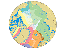
British scientists say they have drawn up the first detailed map to show areas in the Arctic that could become embroiled in future border disputes.
A team from Durham University compiled the outline of potential hotspots by basing the design on historical and ongoing arguments over ownership.
Russian scientists caused outrage last year when they planted their national flag on the seabed at the North Pole.
The UK researchers hope the map will inform politicians and policy makers.
"Its primary purpose is to inform discussions and debates because, frankly, there has been a lot of rubbish about who can claim (sovereignty) over what," explained Martin Pratt, director of the university's International Boundaries Research Unit (IBRU).
"To be honest, most of the other maps that I have seen in the media have been very simple," he added.
"We have attempted to show all known claims; agreed boundaries and one thing that has not appeared on any other maps, which is the number of areas that could be claimed by Canada, Denmark and the US."
The team used specialist software to construct the nations' boundaries, and identify what areas could be the source of future disputes.
"All coastal states have rights over the resources up to 200 nautical miles from their coastline," Pratt said. "So, we used specialist geographical software to 'buffer' the claims out accurately."
The researchers also took into account the fact that some nations were able to extend their claims to 350 nautical miles as a result of their landmasses extending into the sea.
Back on the agenda
The issue of defining national boundaries in the Arctic was brought into sharp relief last summer when a team of Russian explorers used their submarine to plant their country's flag on the seabed at the North Pole.
A number of politicians from the nations with borders within the Arctic, including Canada's foreign minister, saw it as Moscow furthering its claim to territory within the region.
Pratt said a number of factors were driving territorial claims back on to the political agenda.
"Energy security is driving interest, as is the fact that Arctic ice is melting more and more during the summer," he told BBC News. "This is allowing greater exploration of the Arctic seabed."
Data released by the US Geological Survey last month showed that the frozen region contained an estimated 90 billion barrels of untapped oil.
Pratt added that the nations surrounding the Arctic also only had a limited amount of time to outline their claims.
"If they don't define it within the timeframe set out by the UN Convention on the Law of the Sea, then it becomes part of what is known as 'The Area', which is administered by the International Seabed Authority on behalf of humanity as a whole."
PHOTO CAPTION
Arctic Map
BBC

 Prayer Times